Summary
A fast-moving March storm is creating a two-part threat across the eastern United States: dangerous severe thunderstorms from the Southeast into the Mid-Atlantic and blizzard conditions from Wisconsin into Michigan. Forecasters say the most serious severe-weather window will unfold late Monday afternoon into early evening, when volatile air, strong wind shear and an advancing cold front could combine to trigger widespread damaging wind gusts and a few tornadoes.
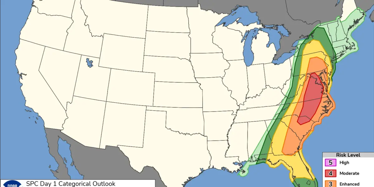
The highest danger zone is centered on central Maryland, much of central and eastern Virginia, central North Carolina and adjacent parts of South Carolina, where a Level 4 of 5 moderate risk has been posted. The broader storm corridor stretches much farther, with severe weather concerns extending up the East Coast and south into Florida. Forecasters say the setup is strong enough that a couple of storms could become long-track tornadoes, especially if isolated supercells can form ahead of the main line.
That puts major population centers directly in the path of the strongest storms. Washington, D.C., Richmond and Raleigh are all in the zone where severe thunderstorms and damaging winds could become a major problem during the evening commute. The primary threats are expected to be destructive straight-line winds, quick-moving tornadoes and heavy rain, with the risk increasing as storms race out of the Appalachians and toward the coast.
The severe-weather threat has already forced changes ahead of the arrival of the storms. Some school systems in Raleigh and Chapel Hill, North Carolina, canceled classes for Monday, and Maryland Gov. Wes Moore declared a State of Preparedness, citing the risk of widespread damaging winds and an elevated tornado threat across the state beginning Monday. Maryland officials urged residents to secure outdoor items, review shelter plans and closely monitor warnings through the day.
Farther north and west, the same sprawling system continues to produce major winter impacts. The Weather Prediction Center said the storm had already dropped as much as 2 feet of new snow from northeastern Wisconsin into parts of upper Michigan, with another 12 to locally 20 inches possible in upper Michigan on Monday. Blizzard conditions were expected to persist through the day as strong north to northwesterly winds wrapped around the storm and kept visibility dangerously low.
The snow and wind are being felt on the power grid as well. In Michigan, about 129,000 homes and businesses were without electricity Monday morning, according to PowerOutage.us, with some northern counties reporting especially severe disruption. The outage map showed Michigan leading the nation in total power outages at that point, underscoring how hard the storm’s wind and snow combination was hitting infrastructure.
Don't miss anything!
Join our community:
The overall pattern remains unusually broad for mid-March. The same cold front driving the Mid-Atlantic severe threat is trailing south through the Southeast, while colder air behind it is set to crash into the South after the storms pass. Official forecast discussions also point to freeze warnings in parts of the Southeast and the potential for snow reaching parts of West Virginia behind the front, showing just how quickly the atmosphere will flip from warm and unstable to sharply colder air.
For travelers, the timing could hardly be worse. Heavy snow has already snarled movement across parts of the Upper Midwest and Great Lakes, while the eastward-moving line of storms threatens to disrupt airports and roads from the Carolinas to the Northeast. Forecasters have warned that the same system is capable of producing major flight delays, downed trees and scattered power outages well beyond the core severe-weather zone.
The biggest message for Monday is straightforward: this is not a routine line of rain and thunder. In the Mid-Atlantic, people in the moderate-risk zone should treat the afternoon and evening hours as a serious severe-weather period and make sure they have more than one way to receive warnings. In the Great Lakes, blizzard conditions and fresh snowfall continue to create dangerous travel and utility problems even as the center of the storm begins to pull away.
Correction note: This report may be updated as forecasts, warnings, outage totals and local impacts change throughout the day.